Assets Map
On this page
Introduction
Using the Asset Map tool in Service Desk, you can identify the approximate physical location of a device connected to the internet. Using GPS, Service Desk uses the IP address's latitude and longitude to provide a location on the map.
Navigation
Assets > Map.
Using the map

You can zoom in and out on the map using CTRL + scroll wheel.
- CTRL + scroll forward zooms in.
- CTRL + scroll down zooms out.
You can click different pins and icons to see more information.
-
Pin. A pin represents a single device.

- Click the pin to see information about the device.
- Click more details to see the asset details screen in Service Desk.
- Icon. An icon with a number on it represents the number of different devices in an area or region.
- Hover over an icon to see the highlighted area/region display behind the icon.
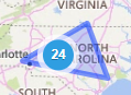
- Click the icon to see pins representing the location of each device. Click a pin to see more information about a device.
- Hover over an icon to see the highlighted area/region display behind the icon.
As the map expands when you click on a pin, you can continue to click icons to drill down to street level, which gives you a better idea of the location of a device.
